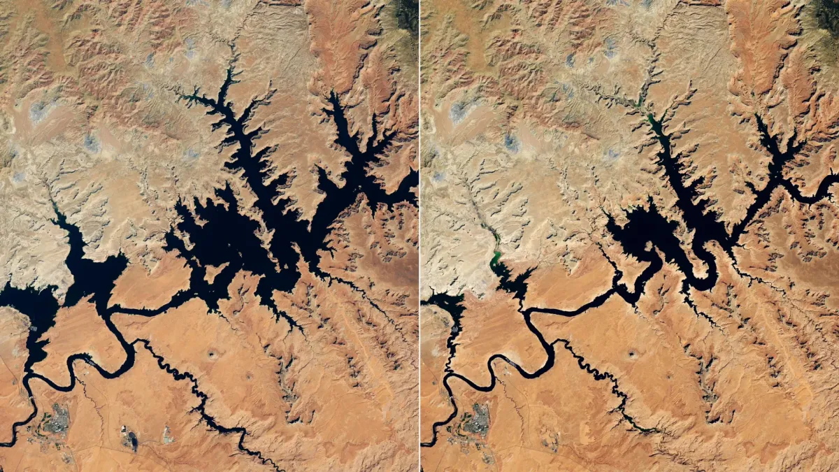
America's second-largest reservoir, Lake Powell, has plunged to a record low, a stark indicator of the severe drought gripping the U.S. West. Unusually warm conditions and a significant snow drought in the Colorado Basin during the 2025-2026 winter led to drastically reduced water flow, pushing the reservoir to its lowest levels in late August and early September.
Satellite images vividly illustrate the dramatic decline. A comparison between September 1, 2017, showing high water levels, and September 10, 2026, reveals a significant shrinkage. By September 2026, Lake Powell's surface had dropped to 3,517.24 feet, falling below its previous record low of 3,519.92 feet set in April 2023. Lake Mead, downstream on the Colorado River, also experienced record lows in August 2026.
The Colorado River system is a vital lifeline for over 40 million people across the Southwest, supplying water and electricity to major cities like Las Vegas, Phoenix, Los Angeles, and San Diego, as well as irrigating millions of acres of farmland. The region's arid climate makes mountain snow crucial, as it's the primary source of the river's annual flow through spring and early summer melt.
The 2025-2026 winter brought a severe "snow drought" to the Upper Colorado Basin and other Western mountain ranges, compounded by record warmth that further diminished the snowpack. This resulted in significantly less snowmelt feeding the Colorado River, failing to replenish already depleted reservoir levels.
In response, the U.S. Bureau of Reclamation initiated emergency measures in April 2026 to stabilize Lake Powell and safeguard hydropower generation. These actions included releasing extra water from Flaming Gorge Reservoir and reducing outflows into Lake Mead. Planned environmental releases, like a "controlled flood" and a "cool mix" release, were also canceled to conserve water.
The U.S. Southwest has been battling a prolonged "megadrought" since the early 2000s, intensifying pressure on its limited water resources. NASA-supported monitoring tools, such as the Western Land Data Assimilation System dashboard and the Drought Severity Evaluation Tool, are providing crucial real-time data to help water managers and policymakers track drought conditions and make informed decisions across the basin.